
Nature Site
Saimaluu-Tash petroglyph
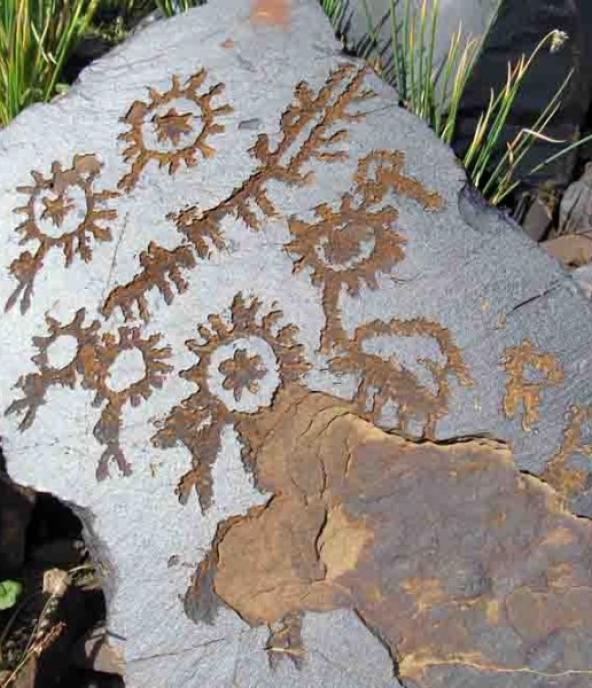
Jalal-Abad Region • Kyrgyzstan • 3100 m
Saimalu-Tash State Natural Park. By car we go 35 km from the center of the district, we have one route, and further those who wish to ride 7 km straight, the road is not a very good trail. Petroglyve occupies a total of 7 hectares. It is located at an altitude of 3100 meters above sea level.Rock paintings were discovered in 1902 by military topographer N.G. Khludov. Their first study in 1903 was conducted by members of the Tashkent circle of amateur archaeologists. At different times the monument was investigated by I. G. Poslavsky, B. M. Zima, G. A. Pomaskina and other scientists. Detailed characterization of the petroglyphs was given by A. N. Bernshtam, who published the results in the journal "Soviet Ethnography". Since 1991, the expedition of the Institute of History of the National Academy of Sciences of the Kyrgyz Republic under the leadership of K. I. Tashbaeva has been studying them. In total, more than 90,000 drawings belonging to different historical periods have been discovered. The first group is about 10 thousand drawings, which date back to the III and II millennia BC and belong to the Neolithic and Bronze Age. The stones depict (in geometric style, i.e. using rectangles or triangles) wild animals, hunting and cultivation scenes. The second group of images dates back to the 1st millennium B.C., the Early Iron Age. These drawings are less detailed, dominated by zoomorphic themes, some of them executed in the famous "Scytho-Saxon animal" style. The third group of drawings dates back to the 1st millennium AD.